 I'm sitting with Kathrin and a liter of ice cold Brahma beer in a bar in the center of misty Lima, beating time until midnight. Depeche Modes "Enjoy the Silence" pounds from the Jukebox, way too loud. We just survived the 20 hour bus ride from Cusco to here, and are now waiting for our flight back to Europe. It's been almost 11 months on the road for me, and 8 with Kathrin. Pictures of the amazing jouney and the last weeks in the Valle Sagrado pass through my mind.
We arrive at 5 AM in Cusco at the bus terminal. An older man approaches us, offers a range of hostales in town. Too tired to send him away, we sip our coffees and eventually follow him to a quiet hospedaje above San Blas. While walking he explains us the Puma design of the town intended by the Inca rulers and some sights on our way up. Climbing the cobblestone steps with our loaded bicycles is a torture, but when we arrive at the Hospedaje Inka we are more than happy with the breakfast in the car-free place with the great view over Cusco and our "suite". Hummingbirds dwell in the yellow blooming trees, and the cat plays with a mice every day in the garden. Five nights we stay, forge plans, stroll the narrow alleys framed by thick stone walls and visit some core tourist sites like Qoricancha and Saqsaywaman. The masons of the Incas left incredible evidence of their excellence in the mighty walls. Within some 200 years their masons cut and joined giant multi-edged and out-of-square stones together that no knife can be put between, and they did this without using metal tools nor wheels nor horses. Just at the peak of the Inca civilization the Spanish conquistadors arrived and succeeded. After their victory they built numerous churches on top of the foundations of the former Inca palaces, which gives the historic city center its incredible touch.
 From Cusco we head to Pisac. We are a little late for the Rainbow gathering in the nearby Lares, so we decide to cycle slowly down the Valle Sagrado towards Machu Picchu, kind of avoiding all the expensive tourist tours, kind of doing things our way and our pace. The Sacred Valley of the Incas is less than a kilometer wide and flat with the Urubamba river, framed by bald rocky slopes and distant snow capped mountains. From Pisac to Ollantaytambo and further down the river various Inca sites tell the story of that once great civilisation.
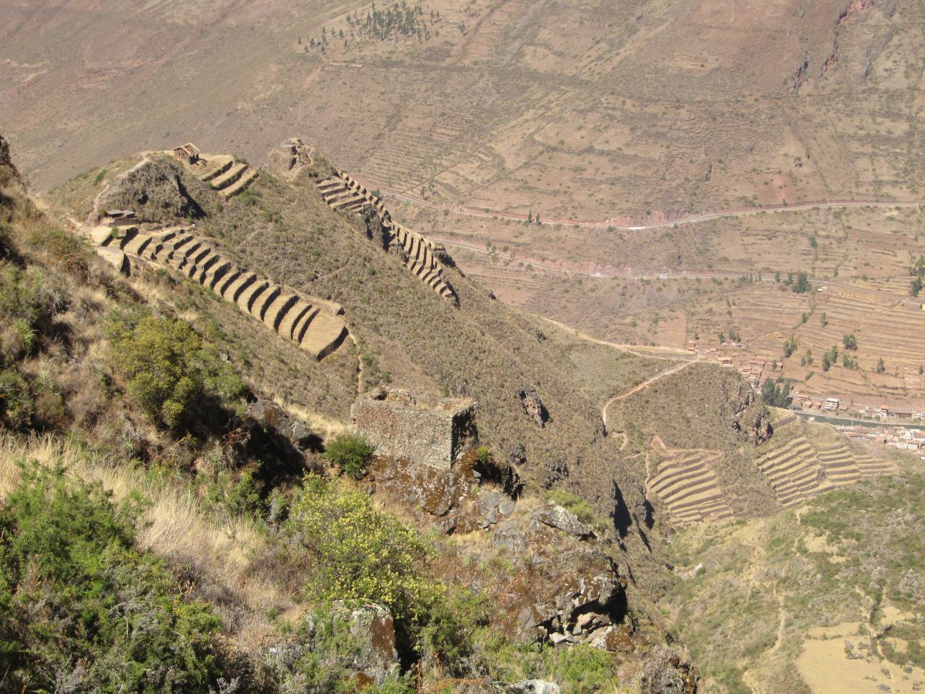
The Spaniards planted a tree on the Plaza of Pisac when they arrived. That tree blossoms red still today, its canopy overlooking the field of souvenir market shacks. Still intact terraces on steep slopes and the picturesque setting of the ruins of Pisac overlook the surrounding valleys and give me a first glimpse what Machu Picchu might be like. The remains of castle and temple buildings are located on the ridge of a rocky hill towering some hundred meters above the village. We hike up early in the morning, barely meeting anyone until the tourist buses arrive about 9AM.
On the outskirts of Urubamba we pitch our tent at a quiet campground run by a German-Peruvian couple for a few nights. From there we visit the agricultural laboratories at Moray. It is a long way up from the Urubamba river to Maras, and still lots of up and down on gravel from that villages to the archeological site. Three giant round sinkholes have been dug here by the Incas, and framed by terrace steps. Scientists say, they used it probably to study crop behavior under the different climatic conditions on the different levels of the terraces. On the way back kids were often begging at us in languages, make us feel uncomfortable. One would eventually hit Kathrin with a whip. I never experienced something like that before.
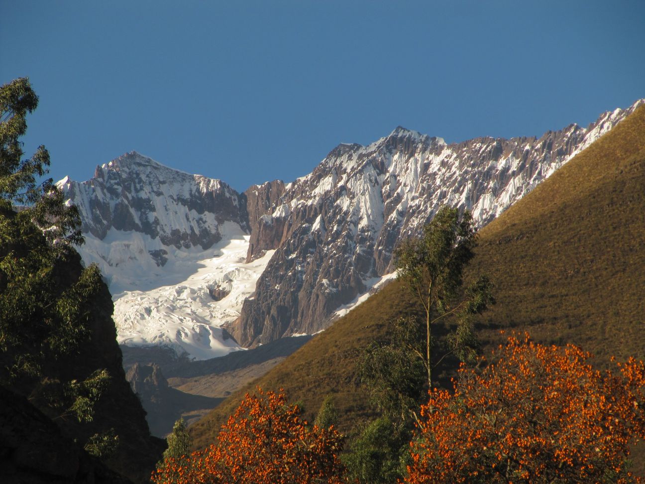
From our campsite in the hardly touristic Urubamba we go hiking in a nearby valley and enjoy the tranquility of the unspoiled landscape near the glaciers of Nevado del Chicon. The visit of the parade of the Virgin Carmen in Pisac and an excursion to the salt producing sites near Urubamba keep us another day on the idyllic campground before we move on to Ollantaytambo.
 |
 |
 |
For the ruins there we take a guide, who explains a lot about the meaning of the word Ollantaytambo, the advanced water system and how the 100 ton heavy rocks for the Temple of the Sun were brought here (without horses). The temple of the sun is actually a set of roughly 3 meter high 4-squared rocks, that have been joined together seamlessly. Looking at the bald hill slopes around us, I can imagine how many trunks of trees were abused for this project. What our guide does not mention is the one successful battle the Incas fought here against the Spanish, which was won by drowning the Spanish in the floods of a opened water reservoir. On the opposite hill are Colchas, old storehouses that could keep crops and corn fresh for months by utilizing the frequent chilly and dry winds. Trails lead to these ruins that are still free to visit. Other than that, Ollantaytambo is the starting point for many tracks as well as the train station to Machu Picchu. Therefore it is fairly crowded by tourists and has great pizza.
{youtube}02m0ZMJHS1g{/youtube}
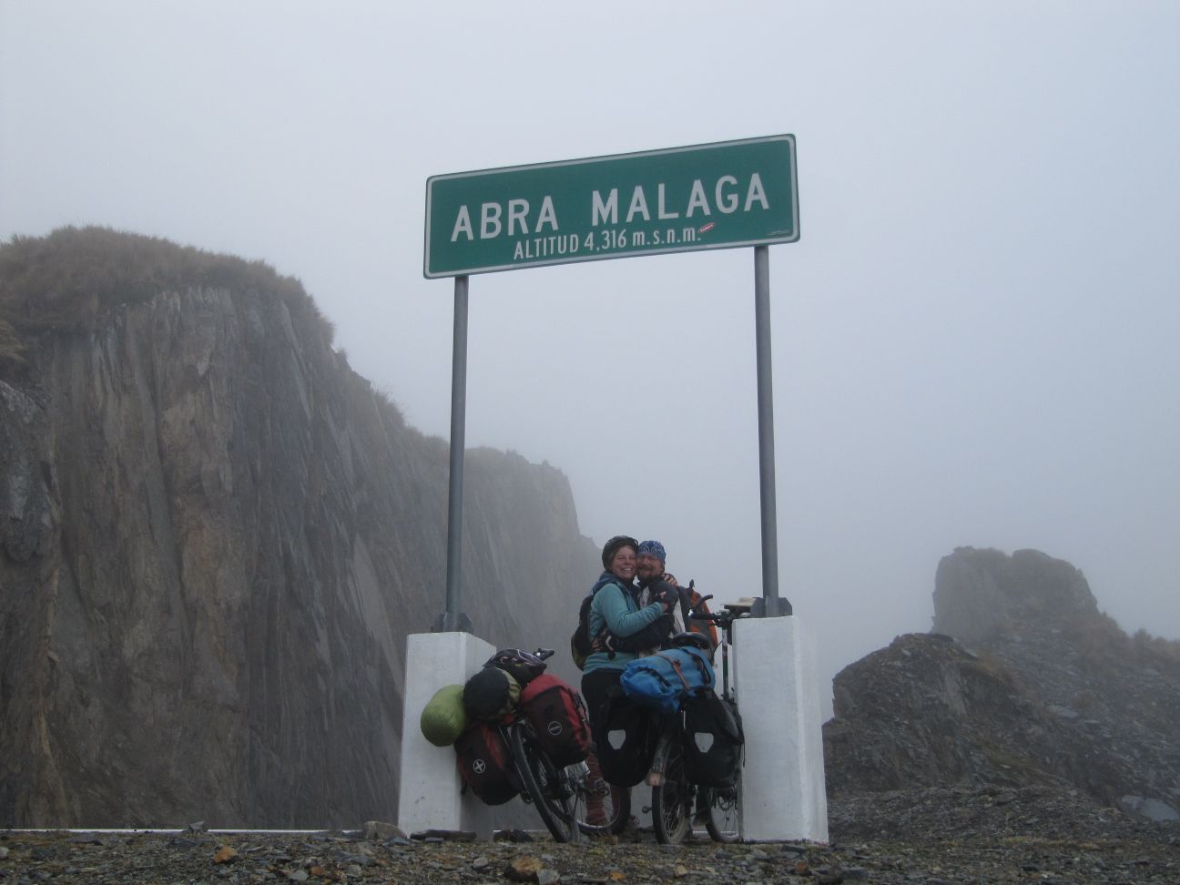
On the following day we set out early in the morning, tackling Abra Malaga with 4300 meters above the sea. It is an amazing scenery to climb up. The road leads through a gap between two giant rocks with endless serpentines through lush green along a wild river and various Inca sites. We reach the pass in the late afternoon. The thick fog that renders to soft cold rain a little later. The awaited downhill ride turns out rather freezy. Soaked to the bone and shivering we reach a small borderhouse restaurant in a tiny settlement on the road just before nightfall. Natty and Pilar, the owners allow us to dry and warm at the wood fire, serve us a great trout diner and let us sleep in a corner of the shack. Business never really stops for Natty, every hour or so some truck driver bangs at the door shouting "Senora, senora, gasolina" or something like that.
Luckily the rain stopped at night, dawn brings blue skies and great views to Mnt. Veronika. We leave the place early, riding down the bumpy road under construction to Santa Maria at about 1100 meters above sea level. Vivid green banana and coffee plantations and temperatures way above 20ºC - we are back in the tropics. With the lack of sleep and motivation we find us a Formula 1 taxi driver that brings us to Santa Teresa in record time - over the dusty gravel death road cornered by steep slopes of the Urubamba canyon. A distant snow capped Mnt. Salcantay revives Kathrins memories on her rainy and misty trek there a few years ago. We put our tent at the hot tubs outside of town, and enjoy the bath before herds of young tourists arrive in tourist vans or on foot. We drink beers and chat with JP, an Californian surfer and Jerome, and author from Belgium.
 |
 |
The next morning we ride two hours up and down on dusty gravel to the train station at Hidro Electrica, where we can store our bikes for a few Soles. The last leg on our way to Aguas Calientes is a very scenic two hour walk along the Urubamba river and the train line. We are already spotting the steep slopes of the rocky walls of Machu Picchu. How does it feel to be so close to the dream destination of this trip! When we arrive, we put our tent a little outside Aguas Calientes on a campsite near the bridge and the bottom entrance of Machu Picchu.
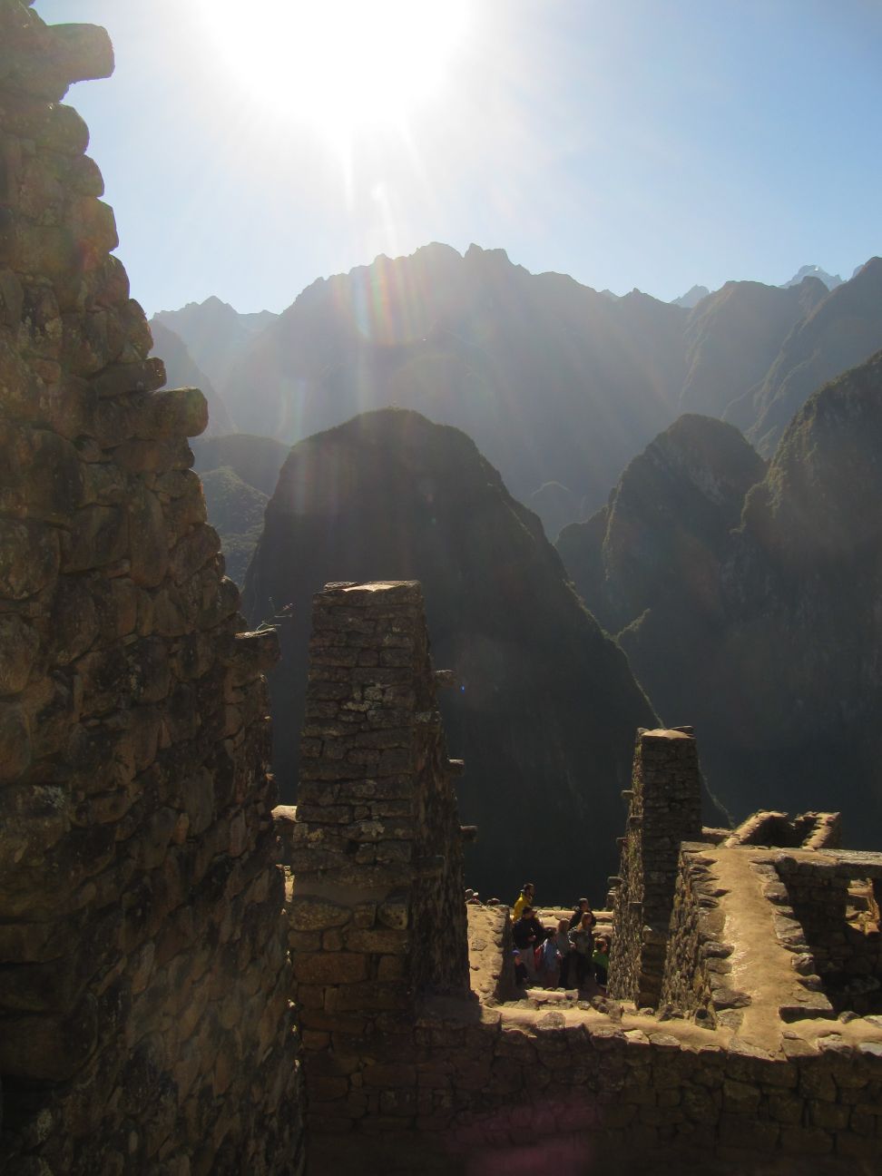
The great day starts funny - we could not hear the alarm and wake up just before 6. So we climb up to the main entrance, some 500 elevation metres. All works out well, and we arrive at the viewpoint terraces of Machu Picchu just in time for a great sunrise on a spotless blue sky! Sipping our self-made ice coffee while watching the sunbeams reaching the peak of Wayna Picchu first, then little by little lightening up the temple ruins - what a feeling! We walk around the ruins after, listening to the guides explanations and marvel upon the architecture of the Incas. When by 9:30 AM the bigger crowds arrive, we are already on our steep way up to Mnt. Machu Picchu. On the way we meet Max from Luxembourg who studies Engineering in Zurich. On top at 3000 meters above sea level a giant rainbow colored Inka flag moves majestically in the winds above the great scenery of the Machu Picchu ruins in front of Mnt Wayna Picchu. In the distance, the white peaks of mnt. Salcantay and mnt. Veronika and other mountain ranges are clearly visible, a 1000 meters beneath us the Urubamba river rushes in his rocky river bed in the narrow S-shaped valley. What a day! Just before we leave the Machu Picchu area, a park ranger tells us a few insights of the Machu Picchu business, e.g. that the very expensive tourist trains are run by Chile and little of the money stays in Peru.
 The hike and bike back to Santa Teresa goes easy. Once again we enjoy the hot tubs, and decide to take a little detour to Quillabamba, wishing to see the rain forests. The 20 kilometres from Santa Maria to Quillabamba turn into a real torture on a very bumpy, very dusty, very busy road. It takes us more than two hours pedalling. When we reach the bustling city, we can't find a peaceful place in town, nor a reasonable way to get into rain forest. So we leave, head back to Abra Malaga by bus, cycle down the scenic serpentines in best weather to Ollantaytambo and finally reach the peaceful campground in Urubamba again. A few more nights there, an incredible Ayuhuasca ceremony of dancing rainbow colored wines in an electric jungle for me, and time is up for this journey of the Americas. A 20 hour bus from Cusco to Lima, some more 20 hours in airports and airplanes, and we are back in Germany.